
Not too long ago, this site had a wealth of articles regarding the Entrance to Aspen and various political issues related to transportation, planning, and the ability of the public to influence government decisions. However, until we find time to return it to its previous glory, it is a repository of images used during the making of
Reality vs City of Aspen – The Entrance
– a presentation at the Wheeler Opera House on February 15, 2023. Images are presented here in the order they were mentioned at the presentation. Legibility is dependent on the source.
Full Version – 1:18:16
Link: https://youtu.be/F3pYl70tX9s?si=AW1kt2KllwShxgRO
Shorter Version Titled: 36 Minutes you really need to watch
The creator of this program is still carrying about 40% of the cost of production. Please help: gofund.me/994b7a2e
A Presentation from 1999 – The Problem With Rail w/Jon Caldara & Wendell Cox – Original Title: The Truth About Rail
IMAGE 1
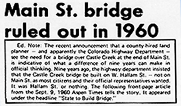
In 1969, The Aspen Times published a recap of how the State Highway 82 bridge over Castle Creek came to be located along Hallam Street, two blocks north of Main Street:
The Aspen Times (weekly) April 17, 1969 — Colorado Historic Newspapers Collection
IMAGE 2:
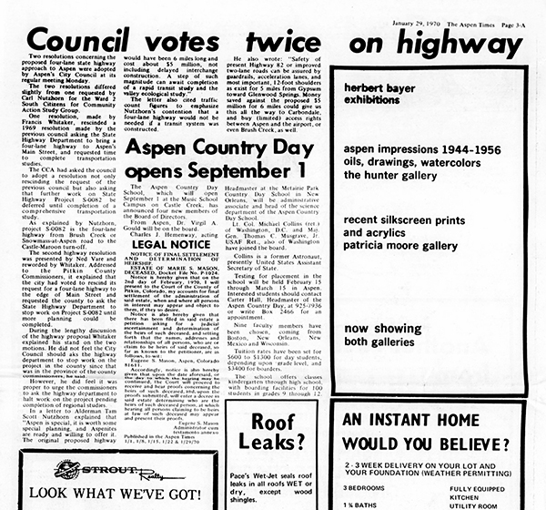
19 days into their administration, the new Aspen city council of 1970 asked the State of Colorado to defer expanding the capacity of Highway 82 while they considered a “rapid transit study”. Due to high mortality rates and the involvement of other political jurisdictions most of the rest of the 18 mile highway has been built, with the current council preventing just the last two miles from being completed.
The Aspen Times (weekly) January 29, 1970 — Colorado Historic Newspapers Collection
IMAGE 3:
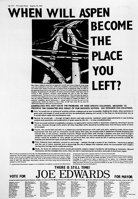
The Aspen Times (weekly) October 23, 1969 — Colorado Historic Newspapers Collection
IMAGE 4:
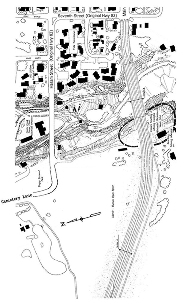
“Direct Connection” – Also known as the “Modified Direct Connection”, depending on the year and the document. In contrast to the photo above, this is what the state actually proposed,
Illustration provided by State of Colorado. See Image 6, below.
IMAGE 5:
At the time of the release of the Highway 82 East of Basalt to Aspen Draft Environmental Impact Statement (DEIS) in 1989, the public clearly knew what it wanted. (See November 6, 1984 Referendum above, and Image 9, below)
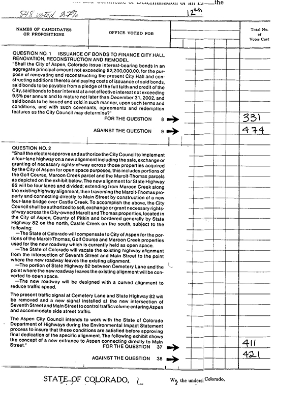
The August 12, 1986 vote above (also Image 10, below) on just the entrance was the first demonstration of how the 75% (or so) who wanted a four lane highway could be defeated by the 25% who wanted the status quo. Also, note the vote totals at this primary election. This outcome was cured in 1990, when the laneage and alignment questions were proposed separately. (See Image 9, below)
IMAGE 6:
This Newsletter was mailed to Aspen voters the week prior to the 1990 vote – authorizing use of the Marolt Property and other parcels acquired for open space. This is the source of the Illustrations in Images 4 & 8.
IMAGE 7:
The original plan, by section:


IMAGE 8:
Illustration of an expanded Highway 82 along the existing alignment.
IMAGE 9:
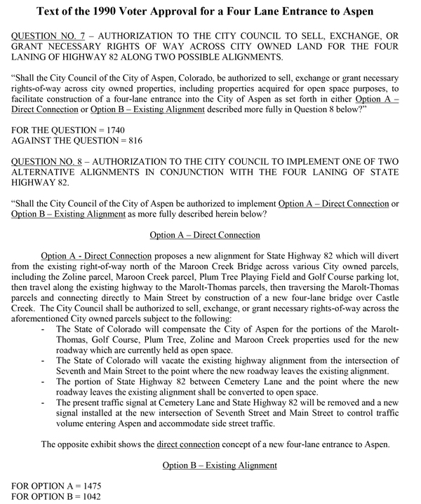
IMAGE 10:
The complete ballot language of the 1986 vote in which proponents of the expansion along the existing alignment combined with the votes of the No-Build faction to defeat the Direct Connection through the Marolt Property. This was seized upon by elected officials as proof that expanding the Entrance to four lanes had been defeated. Compare this with the outcome four years later (Image 9 above).
IMAGE 11:
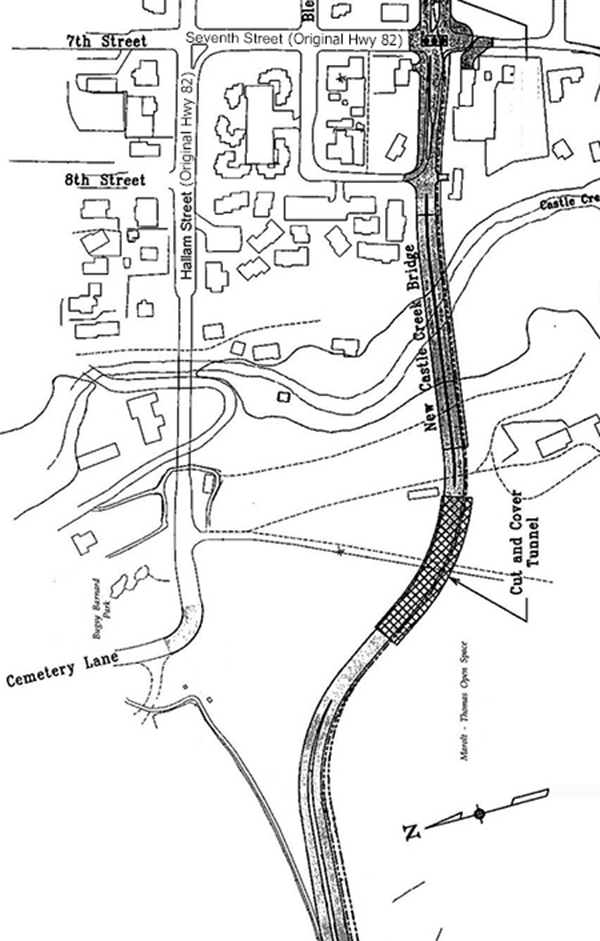
This illustration is useful for seeing the approximate location of the proposed “cut and cover” tunnel.
IMAGE 12A:
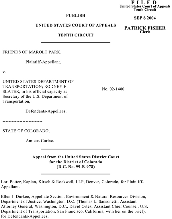
IMAGE 12B:
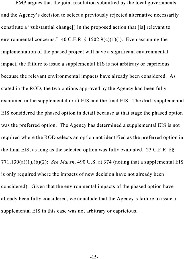
The Friends of Marolt Park case before the United States Court of Appeals, Tenth Circuit, established that any “fully evaluated” option could be built as though it were the “Preferred Alternative”. Without this decision it is likely that the only way forward would be to challenge and overturn the EIS process for the Entrance.
Download Complete File
IMAGE 13A
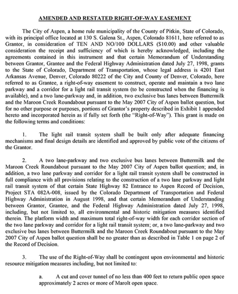
IMAGE: 13B
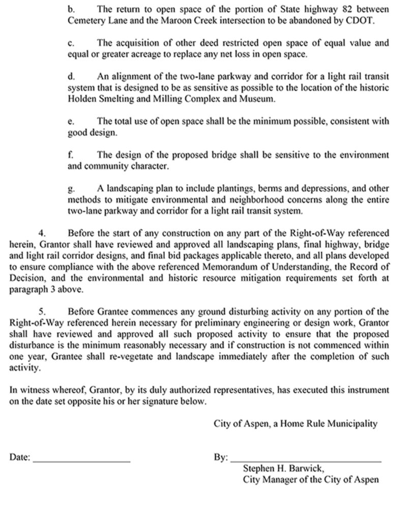
This is the right-of-way agreement which authorizes the transfer of open space land to the State of Colorado. This is the version as amended when the City of Aspen decided to pursue bus lanes prior to building rail. It is an administrative document which could be further amended to prefer any of the fully evaluated options for the Entrance – subject to acceptance by the State of Colorado.
IMAGE 14:
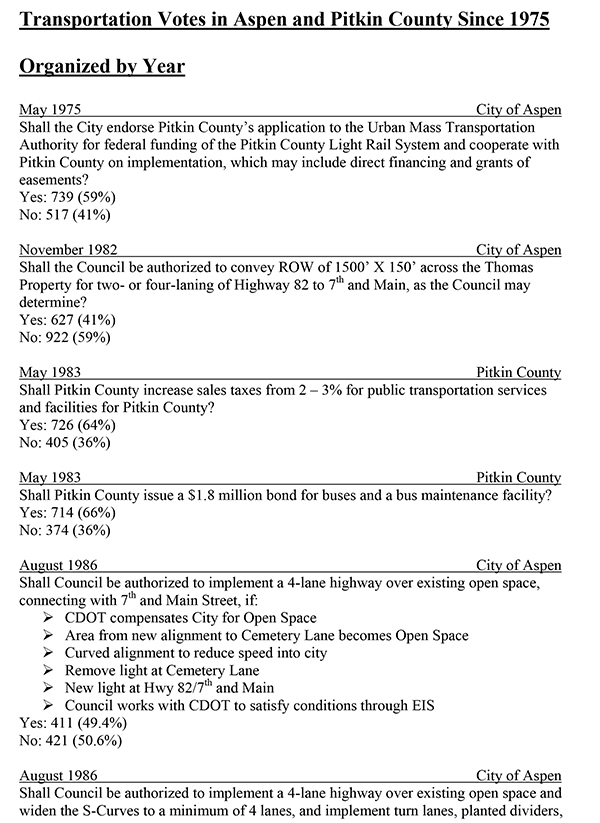
A very peculiar “historical” chronicle featured on the Colorado Department of Transportation website. It omits an overwhelming 1984 vote favoring a four lane highway for the entire length of the Roaring Fork Valley between Aspen and Glenwood Springs.
IMAGE 15:
The Purpose and Need statement from the 1989 East of Basalt to Aspen Draft EIS. The second paragraph is quite straightforward.
IMAGE 16:
The 1995 DEIS Purpose and Need statement begins by proposing “…a transportation solution that addresses the transportation capacity inadequacies…” of the “study corridor”. The substitution of a “study corridor” in place of Highway 82 as the core inadequacy was a semantic fog machine.
IMAGE 17:
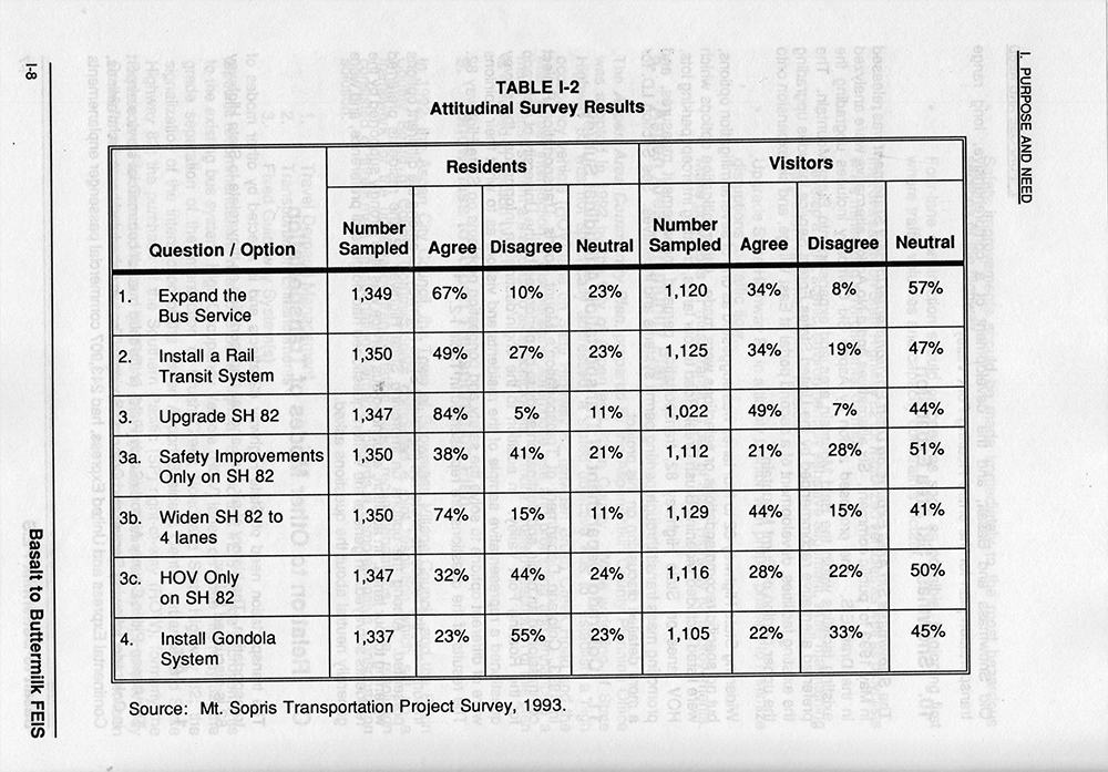
This image is useful as an example of one of the techniques used by CDOT to determine community attitudes. There would not have been any elections if not for the need to obtain voter approval for the change of use of property acquired for open space purposes.
IMAGE 18:
Here, a “transportation system” is substituted for Highway 82 in order to obscure the need for highway capacity improvements.
IMAGE 19:
“The Need for Four Lanes” This statement was placed in the Record of Decision for the East of Basalt to Buttermilk Ski Area portion of Highway 82. This was done by the same people, in the same department of the State of Colorado, who produced the original East of Basalt to Aspen DEIS, and the subsequent Entrance to Aspen Record of Decision.
IMAGE 20:
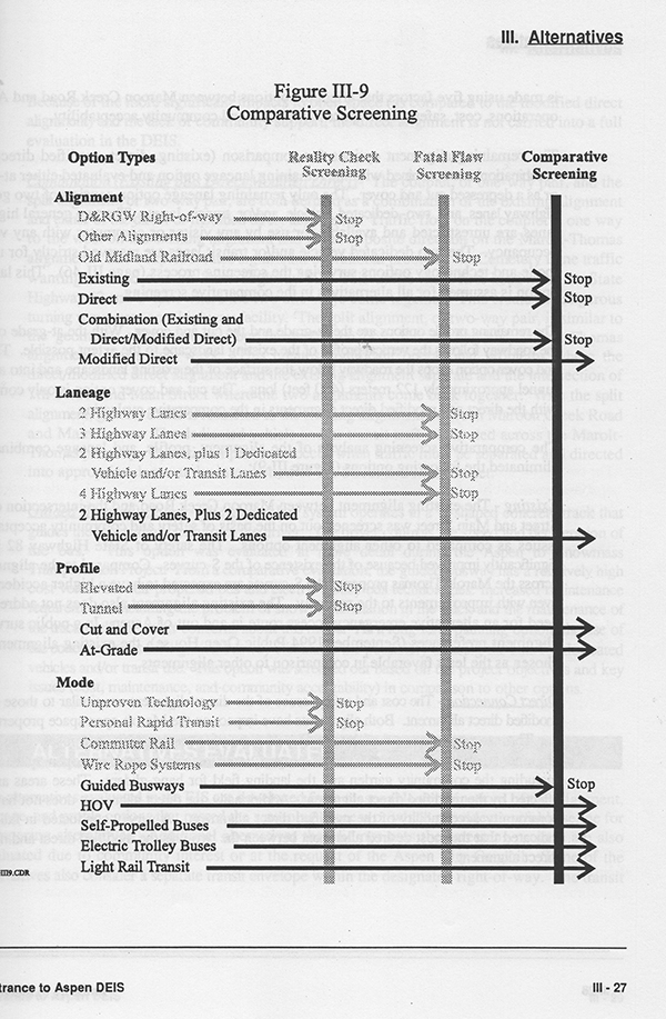
The inclusion of “HOV” in the group of fully evaluated “Mode” alternatives preserved the one possible option to improve the capacity of Highway 82 – as called for in the original purpose and need statement in 1989.
IMAGE 21:
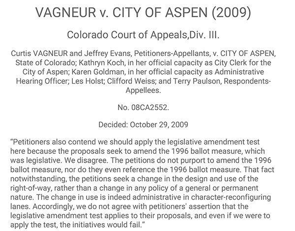
The Colorado Court of Appeals closed the door on any resolution to this issue by the voters – except in their choice of elected representatives.
Download Complete File
IMAGE 22A:
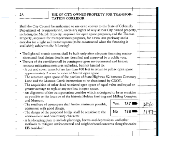
The often mentioned 1996 entrance vote for the use of open space. A legible copy appears below.
IMAGE 22B:
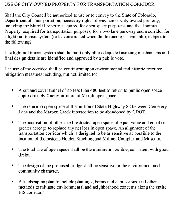
“The light rail transit system shall be built only after adequate financing mechanisms and final design details are identified and approved by a public vote.” This contingency makes the approval nearly useless, and yet it became the basis for the Record of Decision for the Entrance to Aspen. As noted above, the fully evaluated HOV Mode option provides a lifeline out of this mess.
Return to Images 13A and 13B to review the one document which would need to be revised in order to proceed with the HOV Mode alternative for the Entrance to Aspen.